Each week during the wildfire season, Dr. Mike Flannigan will share a five- to 10-day fire weather outlook for Canada. This is a first step in developing a national early warning system for wildfire in Canada. The fire weather outlook will be posted every Tuesday.
Mike Flannigan is the scientific director of the Institute for Wildfire Science, Adaptation, and Resiliency as well as the BC Innovation Research Chair in Predictive Services, Emergency Management and Fire Science at Thompson Rivers University.
View bioWeekly Outlook | July 25-30, 2026 Issued July 21, 2026
All information provided below is reported at the time of publication and may not reflect more recent updates.
Current fire situationMore Fire & Smoke
Throughout this fire season, I have invited colleagues to contribute sections on wildfire-related topics for the outlook. This week, I am pleased to share a contribution on Wildfire Smoke and Health by Dr. Sarah Henderson of the BC CDC (LinkedIn). Dr. Henderson’s contribution appears in italics below.
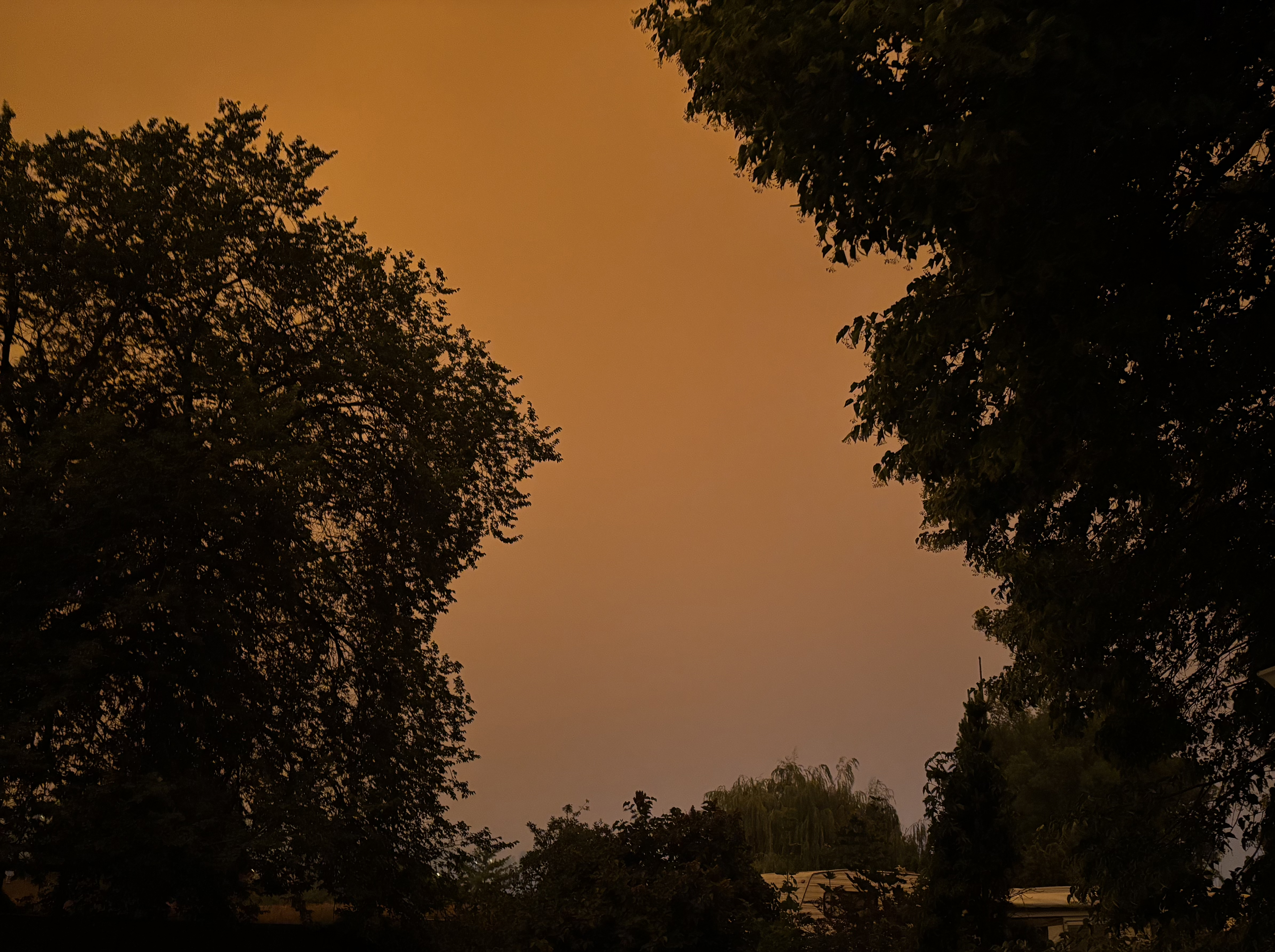
Canadian wildfire smoke has been back on the front-page news this week. Fires burning the territories and northern Ontario have once again turned the skies hazy orange in eastern Canada and the US. If you’re counting, you know this has happened in three of the last four summers. However, the FIFA World Cup added a new twist to the news stories this season, because the terrible air quality coincided with the final match in East Rutherford, New Jersey.
We have long understood that short-term exposure to wildfire smoke is associated with higher rates of many acute health outcomes, including asthma exacerbations and heart attacks. Twenty years ago, we referred to these effects as transient, meaning they would disappear when the smoke cleared. Most populations experienced a severe smoke episode less than once per decade, so the possibility of longer-lasting health effects due to repeated exposures was not an urgent public health concern.
The past 10 years have shown us that exposure to severe wildfire smoke episodes may become an annual reality for people in Canada and other fire-prone parts of the world. As such, the global research community has begun studying the effects of repeated exposures on risk of developing chronic diseases, such as dementia and heart failure. So far, the evidence suggests that wildfire has a strong effect and may be more toxic than air pollution from other sources.
Our team recently developed the Multiyear Wildfire Smoke Exposure (MultiWiSE) metrics to separate ambient air pollution into its wildfire and non-wildfire components over several years. When applied in British Columbia (BC) from 2010-2023, the recent pattern of longer and more severe smoke episodes is clear (Figure 1). We are now using these metrics to study the incidence of multiple chronic disease in BC, particularly those that affect the respiratory, cardiovascular, and central nervous systems.
Here’s what we already know: smoke can adversely affect human health in the short-term and the long-term. Most people spend more than 90% of their time indoors, so the best way to protect public health is to keep the indoor environment as smoke-free as possible. This means reducing smoke infiltration through windows, doors, and other openings in the building envelope, and then actively cleaning the indoor air. Everyone can contribute to our national smoke resiliency by advocating for smoke management plans at home, work, school, and other indoor places where they spend time.
The past few years have been telling us (or, rather, screaming at us) that we must learn to live with wildfire smoke in Canada. The outdoor conditions are not going to improve as the climate continues to change, but we can improve the indoor conditions if we put our minds to it.
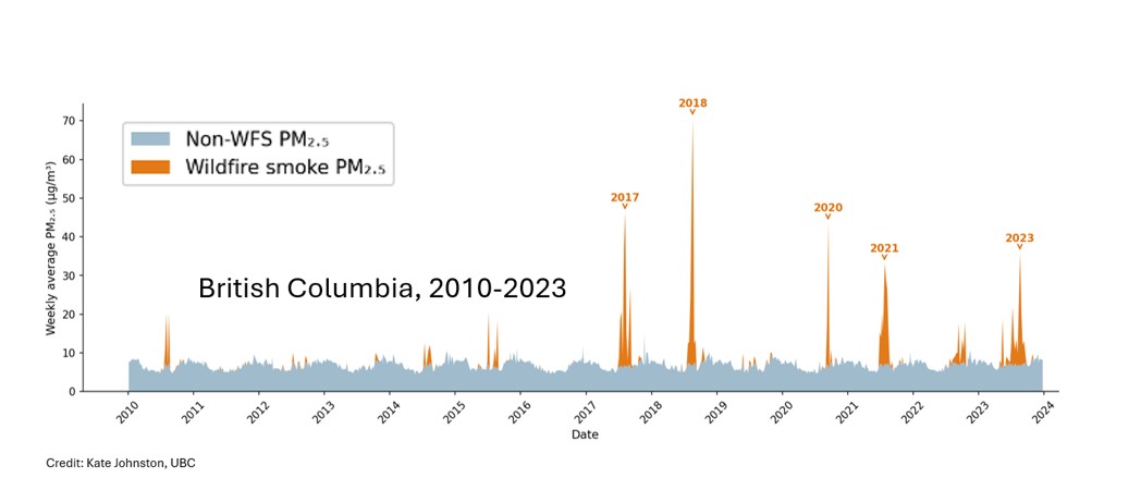 Figure 1: Concentrations of fine particulate matter (PM2.5) from wildfire smoke (WFS, orange) and non-WFS sources (grey) in British Columbia from 2010-2023. Kate Johnston (UBC) created this figure using data from the Canadian Optimized Statistical Smoke Exposure Model (CanOSSEM) and the Multiyear Wildfire Smoke Exposure (MultiWiSE) metrics.
Our fire season is now in high gear, with significant fire activity in Ontario, the Northwest Territories, BC, and Saskatchewan. Figure 2 shows the cumulative area burned in Canada from satellite hotspots and depicts 2026 moving rapidly away from the pack after a quiet start, with only 2023 and 2025 having recorded greater area burned to date. Figures 3 and 4 show cumulative area burned and carbon emissions in Ontario, respectively. Note that in terms of area burned, 2021 holds the top spot, but in terms of carbon emissions, 2026 holds the top spot - both are correct. The reason the 2026 Ontario fires have produced more emissions is that they are more severe, having consumed more biomass through greater depth of burn.
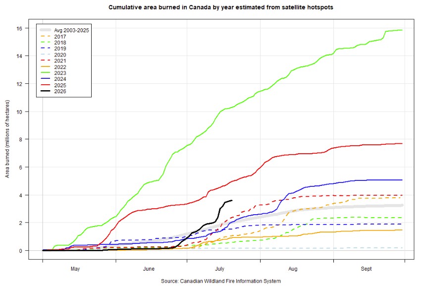 Figure 2. Cumulative area burned in Canada by year, estimated from satellite hotspots.National wildland fire summary
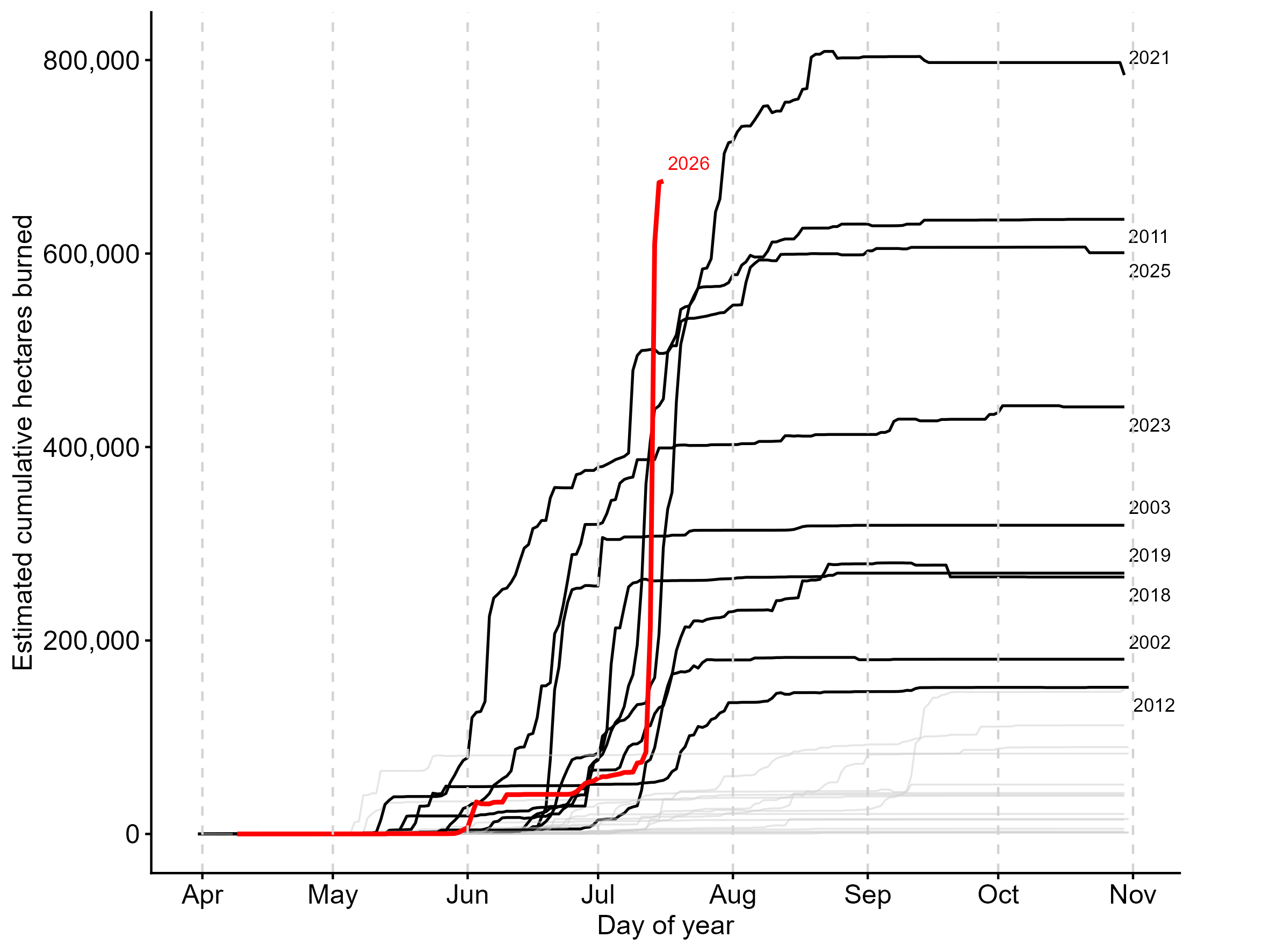 Figure 3. Cumulative area burned in Ontario, 2003-2026.
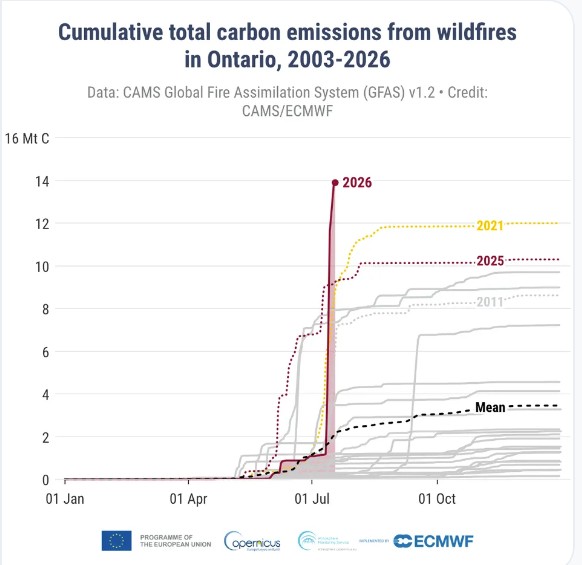 Figure 4. Cumulative total carbon emissions from wildfires in Ontario, 2003-2026.
Fire weather outlook July 25- July 30
Some relief from fire activity is expected across parts of Canada during the outlook period, as many regions receive much-needed rainfall. An upper ridge develops over central North America during the outlook period (Figure 5), which may bring conducive fire weather back to northwestern Ontario. The Northwest Territories will continue to see active fire during the outlook period. Southern BC may remain active despite cooler temperatures. Finally, fires in Labrador may wake up and be active again.
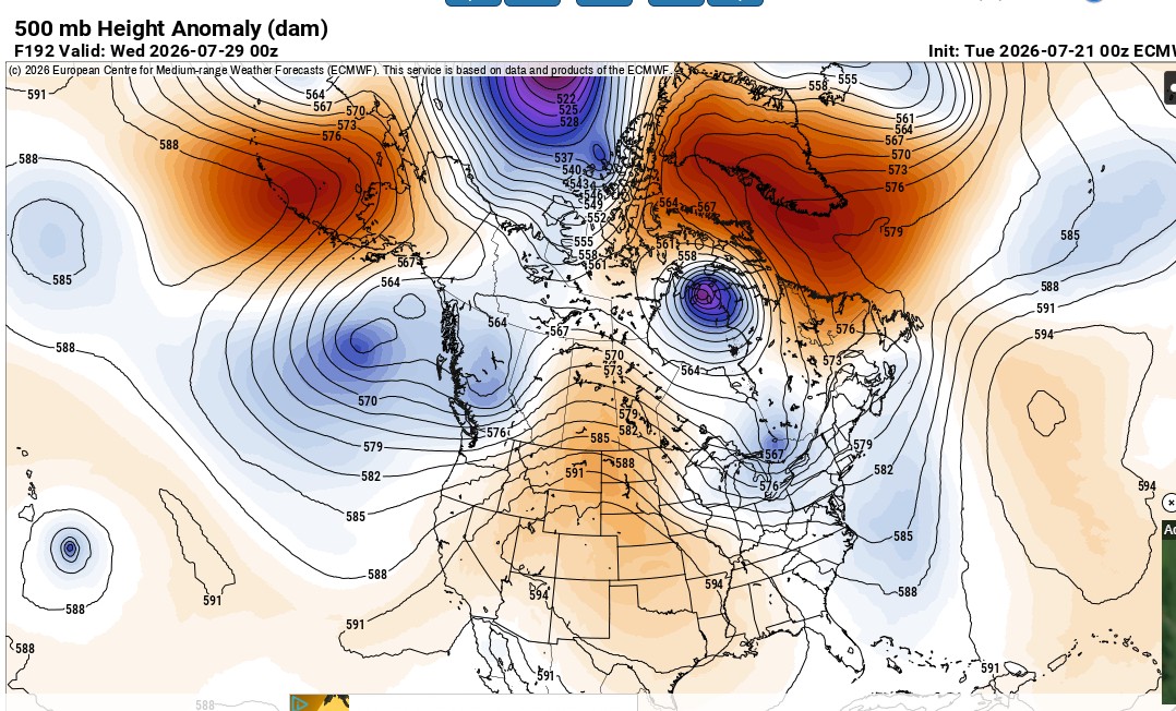 Figure 5. ECMWF 500 mb heights and anomalies, July 28th, 2026.
A look ahead – August - October 2026
Ensemble forecasts for August-October are shown below. Most of Canada is expected to experience warmer-than-normal temperatures, particularly BC. Precipitation is forecast to be near normal across most of Canada, with the exception of drier-than-normal conditions expected for parts of BC and the Rocky Mountains in Alberta. An extended autumn fire season is anticipated, particularly for parts of BC and AB.
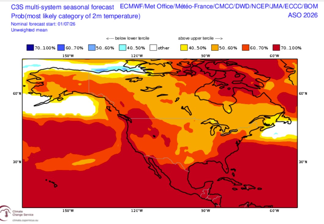 Figure 6. C3S temperature forecast for August – October 2026.
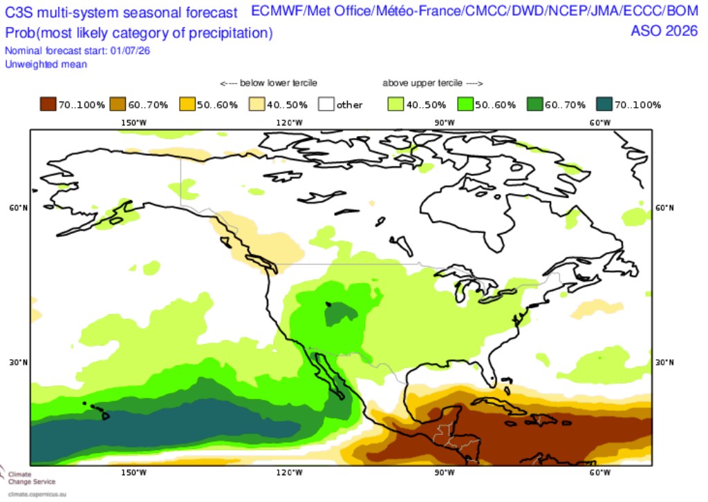 Figure 7. C3S precipitation forecast for August - October 2026.
Weekly forecast history
Questions?We have the answers
Questions, including media requests for Mike Flannigan, can be emailed to wildfire@tru.ca.
Want to keep up with fire weather and fire activity? Check out @mikeflannigan.bsky.social.
Subscribe to the Canada fire weather outlook